Introduction:
For this week's assignment the Geography 336 class at UW-Eau Claire, left the main campus to a subdivision know as the Priory. The Priory is a community campus housing area that is located roughly 3.5 miles away from campus. The surrounding land is recovered woodland from what was previously maintained farm land. The point of this exercise was to use navigation maps that were made prior to this and a simple GPS unit to find and record a set of Universal Transverse Mercator (UTM) coordinates.
Study Area:
As was previously stated, the Priory is located about 3.5 miles away from lower campus. The official address is: 1190 Priory Rd, Eau Claire, WI, 54702. More specifically, class activity occurred in the forested land surround the establishment. Figure 13.1 is a reference map that depicts the surrounding area. The extent of the UTM coordinates is outlined by the black and red shape below.
Methods:
While entering the study area the class was broken into four groups, each receiving a previously made copy of a navigation map (see Navigation Maps, February 2016), a set of five UTM coordinates, and a simple GPS unit. The first step was to use the map to mark down the coordinate points so it could be used as a reference. Then, after the professor ensured that the GPS unit was in fact working, each group set out into the surrounding woods to find and georeference the locations with pictures of each coordinate.
Later, the data (points and tracks) was downloaded onto a shared file, so that it could be further manipulated to create a series of maps. From this activity a series of five pictures and three maps were created.
Results and Discussion:
For each coordinate found, the class was asked to take a picture of the nearest tree. In some cases the tree was marked with pink tape. However this was not the case for all of the locations as some were missing markers either due to natural or human intervention. Below are the five pictures of the locations found.
Right from the beginning of this project, every group had associated problems with the navigation maps previously created. Some of those problems included the wrong coordinate type, scale size, and clarity or resolution. For these reasons, the maps were deemed essentially useless for this project. Thus the main form of navigation was through the GPS unit each group received. On top of this, our group's GPS unit 19 was low on battery. So in order to still have a second source for reference, a webpage was pulled up on a smart phone for the group. This website calculated latitude and longitude from the UTM coordinates received, and then linked the information to google maps for a live feed of the location, direction and proximity to the designated point. In addition to this, a compass app on that same phone was used to make sure, the direction headed stayed to the orientation needed.
Figure 13.3, is the accumulated points that were collected by the four study groups. As can be seen in this map, the locations varied in distance and direction from the initial Priory building. However, in general, each of the groups points were in the same location.
Conclusion:
In conclusion, this activity was fun and interactive. However in retrospect, it would benefit from the proper use of working maps and equipment. Yet all mishaps aside, it taught the class the importance of reference materials when navigating unknown locations and how to react quickly on your feet when faced with unexpected issues.
For this week's assignment the Geography 336 class at UW-Eau Claire, left the main campus to a subdivision know as the Priory. The Priory is a community campus housing area that is located roughly 3.5 miles away from campus. The surrounding land is recovered woodland from what was previously maintained farm land. The point of this exercise was to use navigation maps that were made prior to this and a simple GPS unit to find and record a set of Universal Transverse Mercator (UTM) coordinates.
Study Area:
As was previously stated, the Priory is located about 3.5 miles away from lower campus. The official address is: 1190 Priory Rd, Eau Claire, WI, 54702. More specifically, class activity occurred in the forested land surround the establishment. Figure 13.1 is a reference map that depicts the surrounding area. The extent of the UTM coordinates is outlined by the black and red shape below.
 |
| Figure 13.1: The study area surrounding the Priory student housing establishment. |
Methods:
While entering the study area the class was broken into four groups, each receiving a previously made copy of a navigation map (see Navigation Maps, February 2016), a set of five UTM coordinates, and a simple GPS unit. The first step was to use the map to mark down the coordinate points so it could be used as a reference. Then, after the professor ensured that the GPS unit was in fact working, each group set out into the surrounding woods to find and georeference the locations with pictures of each coordinate.
Later, the data (points and tracks) was downloaded onto a shared file, so that it could be further manipulated to create a series of maps. From this activity a series of five pictures and three maps were created.
Results and Discussion:
For each coordinate found, the class was asked to take a picture of the nearest tree. In some cases the tree was marked with pink tape. However this was not the case for all of the locations as some were missing markers either due to natural or human intervention. Below are the five pictures of the locations found.
 |
| Figure 13.2: Each picture is numbered to represent order that each coordinate point was found. |
Figure 13.3, is the accumulated points that were collected by the four study groups. As can be seen in this map, the locations varied in distance and direction from the initial Priory building. However, in general, each of the groups points were in the same location.
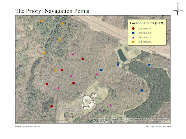 |
| Figure 13.3: The location for each of the points collected by the four separate study groups. |
In correlation to figure 13.3, a second map was developed to show the relative elevation (in meters) that each point was found (figure 13.4). As can be seen, the Priory is located on top of a hill with the surrounding forest sloping down around it. Since this land is reclaimed from farm land, the soil was not very compact and often showed large ravines from run off, and other indicators of erosion. Also due to this, the vegetation associated with it varied from thick underbrush and thorny bushes, to clear ground cover with only taller, more established tree cover.
 |
| Figure 13.4: The location to each point collected in respect to relative elevation. |
Aside from the simple location points collected, each GPS was also tracked the path that each group traveled to find the locations. Yet after reviewing the data in ArcMaps, it was discovered that the GPS unit 19 had only one point recorded on the track, which defeated the purpose of tracking. (Perhaps due to the low battery level?) GPS unit 29 had more points listed however, they were scattered with large distances in between them, making directional orientation hard to establish. For these reasons, the final figure, 13.5, only shows the paths for GPS units 20 and 21.
 |
| Figure 13.5: GPS points and relative tracks to said locations. |
In conclusion, this activity was fun and interactive. However in retrospect, it would benefit from the proper use of working maps and equipment. Yet all mishaps aside, it taught the class the importance of reference materials when navigating unknown locations and how to react quickly on your feet when faced with unexpected issues.
Comments
Post a Comment